West Papua: The Ultimate Guide

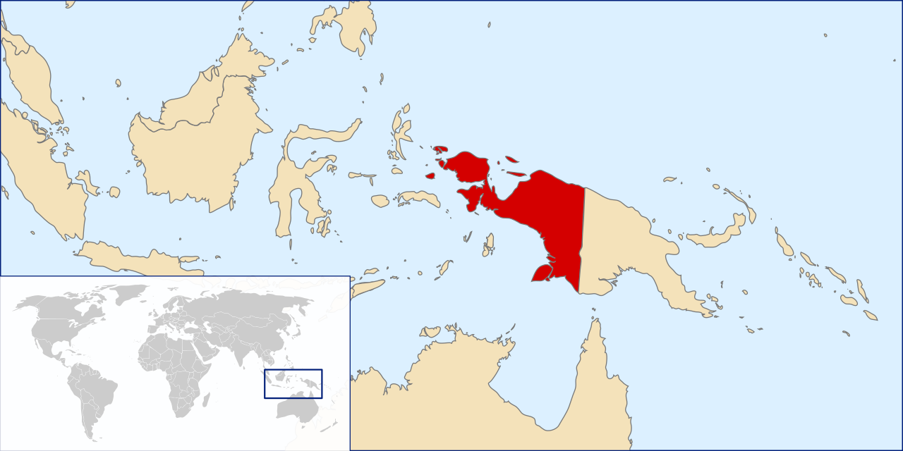
A political map of the New Guinea island, showing the western half divided into the six Indonesian provinces of West Papua, Southwest Papua, Central Papua, Highland Papua, South Papua, and Papua.

I. Introduction: Unveiling the Potential of Indonesia’s Eastern Frontier

The region collectively known as West Papua—spanning the entire western half of the island of New Guinea under the sovereignty of the Republic of Indonesia—stands as one of the most complex cultural, ecological, and geopolitical frontiers in the Indo-Pacific.

To navigate this comprehensive guide effectively, a crucial distinction must be made regarding terminology. In this guide, West Papua refers broadly to the entire Indonesian region of New Guinea encompassing all six modern provinces. Conversely, West Papua Province (Provinsi Papua Barat) specifically denotes the individual administrative unit located in the Bird’s Head Peninsula with its capital at Manokwari.

See also: Fun Facts About the Second Largest Island in the World

The overarching narrative surrounding West Papua often falls into a “paradox,” contrasting its world-renowned West Papua nature with complex human development challenges. Beyond its geopolitical weight, the region boasts unparalleled biodiversity—from the marine sanctuaries of Raja Ampat to dense tropical rainforests harboring endemic species like the Birds-of-Paradise (Cenderawasih). Equally profound is the richness of West Papua culture, shaped by hundreds of distinct indigenous tribes, languages, and ancestral traditions that have coexisted with these landscapes for millennia.

However, a deep analysis of the dynamics in 2024 and 2025 reveals that this regional narrative is shifting towards a structural transition driven by rapid modernization, asymmetric decentralization, and deeper economic integration into Indonesia. To cut bureaucratic red tape and accelerate service distribution across a challenging geography, the single former territory has now expanded into six distinct administrative entities, creating new opportunities for trade, governance, and infrastructure development.

The Dual Meaning of “Independence”

In the socio-political discourse of the region, the concept of “independence” has layered resonances. While August 17th (Indonesia’s Independence Day) is celebrated widely, the date of December 1st often sparks historical debate. Some observers might search for the phrase “happy independence day West Papua” in reference to the 1961 flag-raising event. However, rigorous historical analysis clarifies that the 1961 event was a unilateral administrative act by the colonial Dutch power, not a legally recognized independence, and was later superseded by international agreements like the New York Agreement.

See Also: The Territorial Integration of West Papua: A Legal Analysis of UN Diplomacy and Indonesian Sovereignty


II. Comparative Analysis: West Papua vs. Papua New Guinea

One of the most common queries globally is regarding the difference between West Papua and Papua New Guinea . Although they share the same landmass and identical Melanesian ancestry, they have evolved into two fundamentally different worlds. The border at the 141st meridian east is not just an administrative line; it demarcates distinct colonial histories and political systems.

2.1. Colonial Heritage and Sovereignty

The core difference between West Papua and Papua New Guinea lies in their colonial lineages.

  • West Papua (Indonesia): Was part of the Dutch East Indies. Its integration into Indonesia was finalized through the 1969 Act of Free Choice, recognized by the UN.
  • Papua New Guinea (PNG): Had a fragmented history involving Germany and Britain, later administered by Australia. It achieved sovereignty as an independent Commonwealth realm in 1975.

So, is West Papua part of Papua New Guinea ? No. West Papua is a region within the sovereign state of Indonesia, whereas Papua New Guinea is a separate independent country.

2.2. Political Structures and Demographics

When comparing Papua New Guinea vs West Papua , the governance structures differ sharply.

West Papua operates under Indonesia’s presidential system with “Special Autonomy” status, using Bahasa Indonesia as the sole lingua franca to foster national integration.

Papua New Guinea is a constitutional monarchy with a parliamentary system. It is the most linguistically diverse nation on earth, using Tok Pisin and English to bridge its 840+ languages.

Key Indicators – West Papua vs. Papua New Guinea

IndicatorWest Papua (Indonesia)Papua New Guinea
Political StatusSix integrated provinces of Indonesia with Special Autonomy status.Independent sovereign state; a constitutional monarchy in the Commonwealth.
Main Colonial PowerThe Netherlands (as part of the Dutch East Indies).Germany (north), Britain (south), then Australia (mandate).
Path to Current Status1962 New York Agreement and 1969 Act of Free Choice.Full, internationally recognized independence from Australia on September 16, 1975.
Population (Est.)Around 5.6 million people (mid-2022).Around 11.8 million (official) to 17 million people (UN 2022 est.).
Total Land AreaApproximately 420,540 km².Approximately 462,840 km².
Official Language(s)Bahasa Indonesia.English, Tok Pisin, Hiri Motu, PNG Sign Language.
National/Favorite SportSoccer.Rugby League.
CurrencyIndonesian Rupiah (IDR).Papua New Guinean Kina (PGK).
Human Development Index (HDI)0.655 (average across 6 provinces in 2024).0.568 (Medium), Ranked 154 of 193 countries (2022).
Main Economic DriversMining (Copper, Gold), Forestry, Palm Oil Plantations.Mining (Gold, Copper, Nickel), Oil & Gas (LNG), Forestry.
Main Tourist AttractionsRaja Ampat (diving), Baliem Valley (culture).Kokoda Track (history/trekking), Sepik River (culture), Cultural Festivals.

See also: This is Difference Between West Papua and Papua New Guinea


III. Geography & Administration: The New Map

The administrative and physical landscape of the Indonesian half of New Guinea—broadly referred to by many international travelers as West Papua—has undergone a seismic transformation. To address the vast, challenging geography and accelerate equitable development, the Indonesian government expanded the region into six distinct provinces. This expansion directly answers the search intent for West Papua capital cities, regional governance, and navigating this massive island.

3.1. The Geographical & Infrastructural Reality

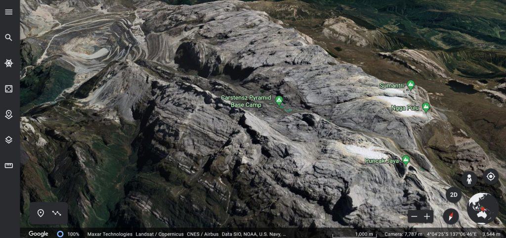
Before diving into the administrative borders, it is crucial to understand the geography that necessitated them. The region is defined by extreme topography: dense tropical rainforests, vast coastal mangrove swamps, steep valleys, and massive river systems. It is also home to the Jayawijaya mountain range, where Puncak Jaya (Carstensz Pyramid) stands as the only snow-capped peak in tropical Southeast Asia.

Because of these rugged terrains, building interconnected provincial road networks remains incredibly challenging. Therefore, accessibility heavily relies on pioneer flights (small propeller aircrafts like Cessna and Twin Otter) to reach highland districts, and maritime routes to connect the coastal cities. This sheer difficulty in logistics and governance across a vast, impenetrable landscape was the primary driver for splitting the region into smaller administrative provinces.

3.2. The Six Provinces: Capitals, Borders, and Regencies

Today, the region is officially divided into six provinces. Here is the complete breakdown of their administrative structures, capitals, and boundaries:

1. Papua Province (Provinsi Papua)

  • Capital: Jayapura – The largest city and the most established economic and administrative center in the entire region.
  • Date Established: Integrated in 1969; reorganized after the 2022 provincial splits.
  • Total Regencies/Cities: 9 (1 City, 8 Regencies).
    • City: Kota Jayapura.
    • Regencies: Jayapura, Keerom, Sarmi, Mamberamo Raya, Biak Numfor, Supiori, Kepulauan Yapen, Waropen.
  • Borders: Pacific Ocean (North), Papua New Guinea (East), Highland Papua & South Papua (South), Central Papua (West).

2. West Papua Province (Provinsi Papua Barat)

  • Capital: Manokwari – Historically significant as the “City of the Gospel” sitting on the scenic Doreri Bay.
  • Date Established: October 4, 1999 (initially as Irian Jaya Barat).
  • Total Regencies/Cities: 7 Regencies.
    • Regencies: Manokwari, Pegunungan Arfak, Manokwari Selatan, Teluk Bintuni, Teluk Wondama, Fakfak, Kaimana.
  • Borders: Pacific Ocean (North), Central Papua & Cenderawasih Bay (East), Banda Sea (South), Southwest Papua (West).

3. Southwest Papua Province (Provinsi Papua Barat Daya)

  • Capital: Sorong – The largest city in the western peninsula. As a major logistics hub, Sorong is the primary gateway to the famous Raja Ampat islands and plays a vital role in maritime trade.
  • Date Established: December 8, 2022.
  • Total Regencies/Cities: 6 (1 City, 5 Regencies).
    • City: Kota Sorong.
    • Regencies: Sorong, Sorong Selatan, Raja Ampat, Tambrauw, Maybrat.
  • Borders: Pacific Ocean (North), West Papua Province (East), Seram Sea (South), Halmahera Sea / Maluku (West).

4. South Papua Province (Provinsi Papua Selatan)

  • Capital: Merauke – Known for its uniquely flat terrain and massive agricultural potential, distinguishing it from the mountainous northern regions.
  • Date Established: July 25, 2022.
  • Total Regencies/Cities: 4 Regencies.
    • Regencies: Merauke, Boven Digoel, Mappi, Asmat.
  • Borders: Highland Papua (North), Papua New Guinea (East), Arafura Sea (South), Central Papua & Arafura Sea (West).

5. Central Papua Province (Provinsi Papua Tengah)

  • Capital: Nabire – Serving as a crucial coastal connecting point and the gateway to the central mountain ranges. It is also home to the massive Grasberg mine in the Mimika regency.
  • Date Established: July 25, 2022.
  • Total Regencies/Cities: 8 Regencies.
    • Regencies: Nabire, Puncak Jaya, Paniai, Mimika, Puncak, Dogiyai, Intan Jaya, Deiyai.
  • Borders: Papua Province & Cenderawasih Bay (North), Papua & Highland Papua (East), Arafura Sea (South), West Papua Province (West).

6. Highland Papua Province (Provinsi Papua Pegunungan)

  • Capital: Wamena (Jayawijaya Regency) – The cultural heart of the highlands. Notably, this is the first and only landlocked province in Indonesia.
  • Date Established: July 25, 2022.
  • Total Regencies/Cities: 8 Regencies.
    • Regencies: Jayawijaya, Pegunungan Bintang, Yahukimo, Tolikara, Mamberamo Tengah, Yalimo, Lanny Jaya, Nduga.
  • Borders: Papua Province (North), Papua New Guinea (East), South Papua (South), Central Papua (West).

See also: Six West Papua Provincial Capital Cities Profile


IV. Demographics: Population & Human Development

The demographics of the region are dynamic and deeply complex, characterized by a vibrant mix of indigenous communities and economic migrants, alongside a young, rapidly growing population. Understanding the people of this region requires looking beyond the regional averages and examining the stark contrasts between bustling coastal hubs and isolated highland valleys.

4.1. Population Trends & Urban Distribution

Current estimates for the West Papua population in 2024 and 2025 indicate a steady upward trend, with the total population across the six provinces reaching approximately 5.6 million.

However, this population is not evenly distributed across the vast 420,540 km² landmass.

  • Urban Concentration: Growth is heavily concentrated in major coastal and economic centers like Jayapura, Sorong, Merauke, and Timika. Newer provincial capitals like Nabire have also seen rapid influxes, with Nabire’s population surging past 178,000 by mid-2024.
  • The Demographic Dividend: The region boasts a notably young population. This youth bulge presents a significant “demographic dividend”—a potential engine for future economic growth, provided that the government continues to invest heavily in vocational education and local job creation.

4.2. The Cultural Tapestry: Indigenous & Migrant Communities

The demographic makeup is a blend of rich ancestral heritage and modern economic migration, shaping a unique socio-cultural landscape:

  • Indigenous Tribes: The region is home to hundreds of distinct indigenous ethnic groups, each with its own language, customs, and traditional lands. From the Asmat and Kamoro woodcarvers in the southern coastal swamps to the Dani and Amungme agriculturalists in the central highlands, and the seafaring Biak people in the north, the indigenous cultural diversity is unparalleled.
  • Economic Migration: Over the decades, demographic shifts have occurred due to historical transmigration programs and spontaneous migration. Settlers from Java, Sulawesi (particularly the Bugis and Makassar), and Maluku have established strong presences, especially in urban commerce and coastal trade, significantly shaping the modern demographics of cities like Sorong and Jayapura.

4.3. Human Development Index (HDI): Progress and the Regional Divide

Contrary to the dominant narrative of stagnation, the Human Development Index (HDI) across the region has shown consistent and tangible improvement, rising from a regional average of 62.76 in 2020 to 65.46 in 2024. This reflects real progress in extending educational facilities, improving healthcare access, and raising per capita income.

Yet, a true understanding of human development here requires acknowledging the HDI disparities:

  • The Coastal Advantage: Urban centers like Jayapura City and Sorong City boast HDI scores that are remarkably high (often exceeding 75), rivaling or even surpassing the national Indonesian average. These cities offer modern hospitals, universities, and robust digital connectivity.
  • The Highland Challenge: In stark contrast, isolated remote regencies—particularly in the newly formed Highland Papua Province (such as Nduga or Pegunungan Bintang)—still grapple with much lower HDI scores.
  • Ongoing Hurdles: In these remote areas, extreme topography creates massive logistical hurdles for development. The government and local NGOs continue to battle pressing developmental challenges, including higher rates of childhood stunting, lower adult literacy rates, and the critical need for better maternal and child healthcare in villages only accessible by foot or pioneer flights.

See also: Comprehensive Analysis of Consistent Human Development Index (HDI) Growth Across Six Provinces in West Papua

V. Culture & Heritage: A Mosaic of Traditions

The cultural wealth of the region is a primary driver of global interest, particularly regarding the myriad West Papua tribes and their unique living traditions. Beyond what meets the eye, this region is an extraordinary linguistic hotspot, home to over 250 distinct indigenous languages—most belonging to the Trans-New Guinea language family—making it one of the most culturally and linguistically diverse places on Earth.

5.1. Indigenous Tribes & Ethnic Distribution

The region is inhabited by hundreds of tribes, each deeply connected to their ancestral lands and possessing distinct customs. Key groups include the Dani and Lani agriculturalists in the central highlands, the Asmat and Kamoro in the southern coastal swamps, and the seafaring Biak people along the northern coast.

To understand the sheer scale of this cultural diversity, the indigenous population is spread across the six modern provinces, each hosting dozens of uniquely identified ethnic groups:

  • Papua Province: Home to the highest concentration of diversity with 125 recognized ethnic groups (including the Sentani, Biak, Waropen, and Skouw).
  • Southwest Papua Province: Hosts 38 distinct ethnicities (such as the Moi, Meybrat, Ayfat, and Tehit).
  • South Papua Province: Home to 38 ethnic groups (including the famous Asmat, Marind, Kombai, and Korowai).
  • West Papua Province: Encompasses 37 ethnic groups (such as the Arfak, Sougb, Irarutu, and Moskona).
  • Highland Papua Province (Papua Pegunungan): Contains 30 distinct tribes (including the Dani, Lani, Nduga, and Yali).
  • Central Papua Province: Home to 26 ethnic groups (including the Amungme, Kamoro, Moni, and Mee).

See also: Complete List of Ethnicities in West Papua Indonesia

5.2. Traditional Attire, Crafts & Accessories

West Papuan traditional clothing is remarkably distinct because it remains largely uninfluenced by outside cultures, maintaining its original forms and functional diversity. The garments worn by men and women vary based on geographical region, age, marital status, and specific cultural occasions.

1. Male Attire & The Iconic Koteka

  • Koteka (Horim/Bobbe): Worn by indigenous men in the highlands (such as the Dani and Yali tribes) to cover the vital parts while leaving the rest of the body bare. It is crafted from mature water gourds (Lagenaria siceraria) that are roasted in hot sand, emptied, and dried over fireplaces before being adorned with bird feathers.
    • Significance: Contrary to common belief, the length or size of a Koteka is determined by activity rather than social rank—short Koteka are used for daily tasks like farming and hunting, whereas longer or uniquely shaped ones (such as the double-gourd style of the Triom tribe) are reserved for ceremonies.
    • Social Cues: The angle at which it is worn indicates social status; a Koteka angled upwards and tilted to the right symbolizes nobility and high status, while a straight, vertical alignment is worn by unmarried men.
    • Modern Context: While historically targeted by assimilation campaigns, it remains preserved in highland regions like the Baliem Valley (Wamena) and is increasingly traded as a cultural souvenir.

2. Female Attire & Marital Status Identifiers

  • Baju Kurung: Influenced by outside trade and widely worn by women in coastal regions like Manokwari for formal cultural events. Crafted from velvet fabric, it is paired with tassel skirts and accented with feather trims around the neck, waist, and arms.
  • Fringe/Tassel Skirt (Rok Rumbai): Worn by women across coastal and island areas (including Yapen, Sentani, Biak Numfor, and Tobati). Made from dried, neatly woven sago leaves, it covers the lower body. During special ceremonies, men may also wear tassel skirts without a top, pairing them with natural body tattoos.
  • Sali: Traditional clothing crafted from specific brown tree bark or dried sago leaves that resembles stitched cloth. It is exclusively worn by unmarried girls for daily activities and is strictly forbidden for married women.
  • Yokal: A woven tree-bark garment with earthy brown or reddish hues worn exclusively by married women in the inland regions to cover their upper bodies.
  • Grass Cloth Garment (Kain Rumput): A traditional fabric adapted with a modern touch, woven from dried sago leaf shoots harvested during high tide and twisted grass strands. It is worn by both men and women.

3. Traditional Accessories & Body Art

  • Indigenous Tattoos: A tradition dating back over 3,000 years introduced by Austronesian migrations. The ink is made from pyrolyzed wood charcoal and tree sap, applied using thorns from sago or animal bones. Tattoos serve as natural tops for the upper body, displaying social status, beauty, and power. Men feature motifs of crocodiles, cassowaries, or sawfish, while women feature endemic fish, eels, or Birds-of-Paradise.
  • Cassowary Feather Crown: Head accessories crafted from white or yellow cassowary feathers (sometimes combined with rabbit fur or thatch), worn as a majestic crown during traditional ceremonies.
  • Noken (Cultural Net Bags): UNESCO-recognized woven bags made from tree bark or rattan roots. Large variants (Yatoo) are suspended from the forehead to carry heavy loads, produce, firewood, or infants, while smaller variants (Gapagoo) carry personal items like betel nut. It remains a prized symbol of Papuan identity.
  • Animal Teeth Accessories (Pig & Dog Teeth):
    • Pig Tusk (Sipet): Placed through the nasal septum of men to indicate warrior status. Facing the tusks downward signifies anger or readiness for battle.
    • Dog Teeth Necklaces (Koyonoo): Made from flawless white dog fangs, these necklaces represent one of the highest forms of traditional wealth in West Papua, utilized as currency for bride prices (dowries) and customary legal fines.

See also: Types of Traditional West Papuan Clothing

5.3. Traditional Architecture & Dwellings

Traditional dwellings in the region are cultural heritages built primarily from organic forest and coastal materials such as ironwood, bamboo, sago foliage, and natural vines. Beyond serving as shelters, these structures act as vital social and spiritual hubs for maintaining customary laws, hosting harvest celebrations, and strengthening tribal bonds.

1. The Dani Settlement Complex (Highlands)

The Dani tribe in the central highlands constructs specialized, gender-segregated and functional structures within a single village compound:

  • Honai (Men’s House): Accommodating 5–6 adult men (Hun = man, Ai = house), the Honai is a circular, windowless building standing 2.5 meters tall and 5 meters wide with a central fireplace to retain heat in cold mountain climates. It is built using hardwoods gathered from central mountain forests for its circular frame, topped with a thick roof of sago leaves, straw, and weeds. Philosophically, the circular design without sharp corners symbolizes unity, equality, and brotherhood among Dani men, while the blunt conical roof offers spiritual sanctuary and physical protection.
  • Ebei (Women’s House): Similar in circular architecture to the Honai, the Ebei (Ebe = body, Ai = woman) serves as the residence for women and children, as well as a sacred space for maternal guidance and moral education. Constructed from sturdy local timber and tightly woven thatch or sago leaves, its name reflects the belief that women represent the “body of life” and the nurturing womb of humanity, embodying the family’s dignity and solidarity.
  • Hunila (Communal Kitchen): An elongated, wide structure constructed using long timber logs wrapped with circular or wooden planks and topped with thick thatch, the Hunila serves as the tribe’s central kitchen where sago and sweet potatoes are prepared and distributed to families. As the hub of food preparation, it represents the vital source of communal energy, care, and equitable social distribution.
  • Wamai (Livestock Shelter): Flexible in layout (varying between circular or rectangular depending on herd size), this shelter houses domestic animals such as pigs, chickens, and goats using harvested forest wood, flexible timber pillars, and dry foliage that can be easily maintained. This architectural adaptability demonstrates practical coexistence with domestic animals, which hold high economic and ceremonial value in tribal rituals.

2. Specialized Cultural & Educational Dwellings

  • Kariwari (Tobati-Enggros Tribe): A three-tiered, non-residential building constructed from water-resistant ironwood, split bamboo panels, and layered sago palm leaves. The first floor trains young boys into adulthood, the second hosts council meetings for chiefs, and the third is reserved for divine worship. Its distinct octagonal pyramid roof is engineered to withstand extreme coastal winds, with the eight sides symbolizing the spiritual alignment between humans, ancestors, and the Divine.
  • Jew / Bachelor House (Asmat Tribe): Measuring 15 by 10 meters, this massive elevated stilt house is constructed using heavy ironwood (kayu besi) bound together with selected natural rattan roots without modern metal nails. It is strictly reserved for unmarried men and elders to conduct custom deliberations, artistic practices, and conflict resolution, serving as the spiritual heart of the Asmat community and symbolizing leadership, maturity, and the transmission of tribal art and governance.
  • Rumsram (Biak Numfor Tribe): Standing 6–8 meters high, the Rumsram is a rectangular, non-residential educational sanctuary for young coastal men, constructed from water bamboo, sago fronds, tree bark, and dried sago leaves. Its most striking feature is a roof shaped like an upside-down boat, which pays homage to the seafaring identity and maritime mastery of the Biak people while cultivating navigation skills and moral codes in the next generation.

3. Environmental Adaptations & Canopy Dwellings

  • Tree House (Korowai Tribe): Built high in living canopy trees (such as banyan trees) using harvested branches, bamboo, foliage, and rattan ties, these iconic dwellings are elevated 15 to 50 meters off the ground. This high-altitude construction demonstrates extreme self-preservation, providing physical protection against wild animals while offering spiritual safety from Laleo (malicious nocturnal spirits of local legend).
  • Mod Aki Aksa / Millipede House (Arfak Tribe): Built on hundreds of densely driven, vertical timber foundation posts that give it the appearance of a millipede, this stilt-style dwelling features interlocked wood or bark walls, thatch roofing, and woven rattan flooring. The dense forest of supporting stilts represents collective strength, unity, and mutual protection within the Arfak community against physical threats and harsh weather conditions.

See also: Types of West Papua Traditional Houses

5.4. Communal Feasts & Culinary Heritage

Traditional food in the region is deeply tied to community bonding and the surrounding geography.

  • Bakar Batu (Stone-Burning Feast): A profound highland tradition where communities cook pork, sweet potatoes, and vegetables using scorching hot stones buried in an earth pit. This feast is the ultimate symbol of gratitude, peacemaking, and communal unity.
  • Papeda & Sago: In the coastal and lowland areas, the staple diet revolves around sago starch. It is commonly processed into Papeda—a thick, translucent, glue-like porridge that is typically served with a savory, yellow-spiced fish broth (Ikan Kuah Kuning).

5.5. Arts, Music, & Festivals

The region’s artistic expression is vibrant, highly spiritual, and globally recognized.

  • Asmat Woodcarving: The Asmat tribe is world-renowned for their spectacular and intricate wood carvings. These artifacts, which represent ancestral spirits, are highly sought after by international museums and art collectors.
  • Tifa & Traditional Dance: The rhythmic beating of the Tifa (a traditional hourglass-shaped wooden drum covered with lizard skin) drives communal dances like the Sajojo or Yospan. These dynamic dances celebrate friendship, harvest, and welcome guests.
  • Baliem Valley Festival: Held annually in Wamena, this internationally famous cultural festival brings together various highland tribes. It features spectacular mock tribal warfare, traditional dances, and a display of vibrant ancestral attire, serving as a massive draw for cultural tourism.

6.1. The Historical Roots: From Colonial Disagreements to Trikora

The territorial status of West Papua—historically designated as Netherlands New Guinea or West Irian—became a major point of contention during the 1949 Round Table Conference (RTC). The Dutch authorities excluded West Papua from the formal transfer of sovereignty to Indonesia, arguing that the Melanesian population required a separate administrative path toward self-government.

Conversely, Indonesia asserted its legal claim based on the well-established customary international law doctrine of uti possidetis juris (“as you possess, so you shall possess”). As validated by the International Court of Justice (ICJ) in cases like Burkina Faso v. Mali (1986) and reinforced by the Chagos Archipelago Advisory Opinion (2019):

  • Post-colonial state borders automatically lock into place along the established administrative boundaries of the predecessor colonial power.
  • As the sole legal successor state to the Netherlands East Indies, Indonesia’s sovereign borders encompassed the entire colonial matrix from Sumatra to West Papua.
  • Unilateral attempts by a colonial power to detach a segment of a territory prior to independence violate international law regarding territorial integrity.

By December 1961, President Sukarno launched the Trikora (Tri Komando Rakyat) campaign and established the Mandala Command under Major General Suharto. To prevent a major regional conflict, the United States mediated negotiations under UN auspices.

6.2. The 1962 New York Agreement & UNTEA Transition

Signed on August 15, 1962, by Indonesian Foreign Minister Subandrio and Dutch Foreign Minister Joseph Luns, the New York Agreement was a binding international treaty under the doctrine of pacta sunt servanda. Validated by UN General Assembly Resolution 1752 (XVII) and registered in the UN Treaty Series (UNTS Vol. 437, No. 6311), the treaty established a peaceful transition process.

For the first time in its history, the UN assumed direct executive governance over a territory through the United Nations Temporary Executive Authority (UNTEA) and its military arm, the United Nations Security Force (UNSF).

ComponentCivilian Component: UNTEAMilitary Component: UNSF
Legal BasisArticle II of the 1962 New York AgreementNew York Agreement & UN Resolution 1752
LeadershipCivilian Administrator (José Rolz-Bennett & Jalal Abdoh)Force Commander (Brigadier General Said Uddin Khan)
PersonnelUN Officials, local Papuan staff, & Indonesian administratorsPakistani Infantry (~1,500 personnel), US & Canadian air logistics
Primary FunctionManaging civilian governance, courts, & bureaucratic transitionsMonitoring ceasefires, disarming Dutch forces, & maintaining order
DurationOctober 1, 1962 – May 1, 1963August 18, 1962 – April 30, 1963

On May 1, 1963, UNTEA officially transferred full administrative authority over the territory to the Government of the Republic of Indonesia, carrying the legal obligation to facilitate an act of self-determination before the end of 1969.

6.3. The 1969 Act of Free Choice (Pepera)

Article XVIII of the New York Agreement mandated an act of self-determination conducted “in accordance with international practice.” In the 1960s, international law did not mandate direct individual voting (“one man, one vote”) as the sole valid mechanism for self-determination; the UN routinely accepted flexible methods tailored to local sociological realities.

Indonesia utilized the traditional consensus-building mechanism of musyawarah mufakat—a concept explicitly incorporated into the official English UN treaty text. This decision was anchored by two realities:

  1. Sociological Reality: The native population lived within traditional tribal structures bound by customary law (adat), where major decisions were built through consensus led by tribal elders rather than individualistic voting.
  2. Geographical Force Majeure: The extreme topography, lack of terrestrial infrastructure, and remote settlements made organizing individual elections across 800,000 scattered citizens a logistical impossibility within the mandated deadline.

Between July 14 and August 2, 1969, the Indonesian government conducted consultations across all eight administrative regencies via the Act of Choice Consultative Councils (Dewan Musyawarah Pepera / DMP), involving 1,026 representative councilors:

Administrative RegencyDate of Pepera ExecutionDMP MembersOfficial Consensus Outcome
MeraukeJuly 14, 1969175 CouncilorsUnanimous decision to remain with Indonesia
JayawijayaJuly 16, 1969175 CouncilorsUnanimous decision to remain with Indonesia
PaniaiJuly 19, 1969175 CouncilorsUnanimous decision to remain with Indonesia
FakfakJuly 23, 196975 CouncilorsUnanimous decision to remain with Indonesia
SorongJuly 26, 1969110 CouncilorsUnanimous decision to remain with Indonesia
ManokwariJuly 29, 196975 CouncilorsUnanimous decision to remain with Indonesia
BiakJuly 31, 196997 CouncilorsUnanimous decision to remain with Indonesia
JayapuraAugust 2, 1969144 CouncilorsUnanimous decision to remain with Indonesia

UN Representative Fernando Ortiz-Sanz, appointed by the UN Secretary-General to oversee the process, submitted his final report (UN Doc A/7723). While noting procedural reservations regarding political surveillance, Ortiz-Sanz formally concluded that an authentic act of self-determination had taken place and reflected the genuine collective will of the population.

6.4. International Recognition: UN Resolution 2504

The definitive multilateral validation occurred on November 19, 1969, when the UN General Assembly adopted Resolution 2504 (XXIV). The electronic roll-call vote delivered a decisive outcome:

  • Yes / In Favor: 84 Member States (73.7%)
  • No / Against: 0 Member States (0.0%)
  • Abstain: 30 Member States (26.3%)

With zero negative votes, the United Nations formally accepted the report and final outcomes. Under standard UN diplomatic language and the legal principle of res judicata (a matter finally decided by supreme authority), Resolution 2504 permanently concluded UN oversight, releasing Indonesia from further obligations under the New York Agreement and solidifying West Papua as an inseparable part of the Unitary State of the Republic of Indonesia.

See also: The Legal Foundation of West Papua’s Territorial Integration


VII. Tourism: Hidden Paradises

The western half of New Guinea reigns as one of the ultimate frontiers for natural beauty and cultural heritage. From the snow-capped equatorial peaks and vast savannas to the world’s richest coral reefs, the region hosts some of the most ecologically significant eco-tourism destinations on the planet.

7.1. Global Marine & Coastal Wonders

The coastal and island networks offer world-class marine biodiversity, historic maritime trade ports, and untouched beaches.

  • Raja Ampat Archipelago (Southwest Papua Province): Located in the new Southwest Papua province, Raja Ampat covers 4.6 million hectares of land and sea. Celebrated for its iconic turtle-shaped karst islands and pristine underwater gardens, it holds 75% of the world’s known marine species, making it the absolute crown jewel of global marine diving.
  • Cenderawasih Bay National Park (Central Papua & Papua Provinces): With its primary entry point at Nabire, this vast marine national park is globally renowned for its resident population of whale sharks (Rhincodon typus). These gentle giants can be observed year-round alongside traditional fishing platforms (bagan).
  • Fakfak & Kaimana (West Papua Province): Known historically for its ancient spice trade, Fakfak features the remarkable Kiti Kiti Waterfall, which cascades directly into the ocean. Nearby Kaimana is famous for its sunset panoramas, earning it the title of the “Twilight Kingdom.”
  • Base-G Beach (Papua Province): Located in Jayapura City (and locally known as Tanjung Ria Beach), this tranquil shoreline originally served as an Allied military base during World War II. Today, it offers calm waves and pristine white sands along the northern coast.
  • Wafsarak Waterfall (Papua Province): A tranquil, family-friendly rainforest escape in North Biak. This 10-meter-high waterfall sits conveniently near the main road, featuring a clear natural pool surrounded by lush foliage.

7.2. High-Altitude Cultural & Alpine Wonders

The central mountain backbone contains high-altitude valleys and UNESCO-protected wilderness areas.

  • Lorentz National Park (Central & Highland Papua Provinces): Spanning a colossal 2,505,600 hectares across 10 districts, Lorentz is a UNESCO World Heritage site and the largest national park in Southeast Asia. Accessible via Timika, Wamena, or Enarotali, it protects the most complete ecosystem in the Asia-Pacific—stretching from tropical seas to the equatorial glaciers of Puncak Jaya. It shelters rare fauna such as the Dingiso tree kangaroo, long-tailed bird of paradise, and snow quail.
  • Baliem Valley (Highland Papua Province): Tucked within the Jayawijaya Mountains just 27 km from Wamena City, this 1,600 $\text{km}^2$ valley sits at high altitude, providing cool mountain air. Home to the Dani, Yali, and Lani tribes, it serves as the cultural heart of the highlands, attracting international travelers annually to the iconic Baliem Valley Cultural Festival.

7.3. Freshwater Lakes & Savanna Ecosystems

The lowlands feature massive freshwater networks and expansive wildlife habitats.

  • Wasur National Park (South Papua Province): Located in Merauke Regency, this 413,810-hectare park features the largest savanna forest in Asia. Hosting six distinct ecosystems, it is a haven for migratory birds, cassowaries, and wallabies, earning it the reputation as the “Serengeti of Papua.”
  • Lake Sentani (Papua Province): The pride of Jayapura Regency, Lake Sentani covers 9,360 hectares and is fed by 14 rivers. Shaped like an amoeba and dotted with 22 inhabited islands, the lake produces up to 1,823 tons of fish annually while offering a unique blend of lakeside indigenous culture and scenic tranquility.

See also: 7 Most Beautiful Tourist Destinations in West Papua


VIII. Nature: From Equatorial Glaciers to the Coral Triangle

The natural landscape of the region is defined by extreme geographical contrasts, spanning from the highest alpine peaks between the Himalayas and the Andes down to the richest marine habitats on Earth. Lying east of the Lydekker Line, the territory belongs to the Australasian biogeographic realm, meaning its flora and fauna are entirely distinct from the western islands of Indonesia.

8.1. The Highest Peaks & Tropical Glaciers

The region is famously home to the highest mountain in West Papua and all of Oceania, the Carstensz Pyramid (Puncak Jaya), standing proudly at 4,884 meters above sea level.

  • Tropical Glaciers: Puncak Jaya is one of the extremely rare locations on Earth where permanent ice exists on the equator. However, these ancient equatorial glaciers are currently retreating at a rapid pace due to the severe impacts of global climate change.
  • Other Major Peaks: The rugged central Jayawijaya mountain range also features other formidable, high-altitude summits, including Puncak Mandala (4,760 masl) and Puncak Trikora (4,750 masl).

8.2. Lowland Rainforests & Australasian Fauna

Descending from the alpine tundra, massive lowland tropical rainforests and sago swamps blanket the region, acting as a crucial lung for the Earth. Because the island sits firmly in the Australasian zone, its wildlife is dominated by unique marsupials and monotremes rather than Asian mammals.

  • Endemic Fauna: The dense forest canopies support breathtaking biodiversity, including the iconic Birds of Paradise (Cenderawasih), the elusive Tree Kangaroo, and the rare egg-laying mammal, the Echidna. On the forest floor, the giant flightless Cassowary roams the undergrowth.
  • Floral Diversity: The varied, extreme topography creates unique microclimates that support thousands of endemic orchids and towering hardwood species perfectly adapted to the deep jungle.

8.3. Marine Life: The Heart of the Coral Triangle

In the western archipelago, Raja Ampat operates primarily as a massive maritime sanctuary, with water covering roughly 80 percent of its administrative territory. Comprising 610 distinct islands—only 35 of which host human settlements—it is globally recognized by scientists and conservationists as the very heart of the World’s Coral Triangle.

  • The Global Epicenter: The Coral Triangle is a virtual geographic boundary spanning across six nations: Indonesia, Malaysia, Papua New Guinea, the Philippines, the Solomon Islands, and Timor-Leste. While it represents only 1.6 percent of the planet’s total ocean area, it houses an astonishing 76 percent of all known coral species and 37 percent of the world’s reef fish.
  • Indonesia’s Contribution: Recent data from the Indonesian National Research and Innovation Agency reveals that Indonesia contributes nearly 46 percent of the total reef area within this global triangle. Supported by strict local government management, the vibrant coral reefs of Raja Ampat continue to flourish, setting the global standard for marine biodiversity.

Leave a Reply

Your email address will not be published. Required fields are marked *