Geophysical Mount Carstensz Facts
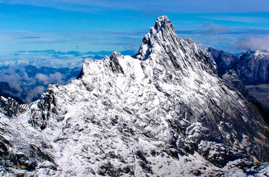
Carstensz Pyramid, officially integrated into the sovereignty of the Republic of Indonesia under the name Puncak Jaya, represents a highly significant geological and geographical anomaly in the tropical region. Among the most fascinating Mount Carstensz facts is that it stands within the Sudirman Mountain range in Mimika Regency, Central Papua Province, soaring to an absolute altitude of 4,884 meters (16,024 feet) above sea level. This elevation establishes Carstensz Pyramid as the highest peak in Indonesia, the highest island peak on Earth, and the highest point in the continents of Australia and Oceania (Australasia).
Geomorphologically, the Late Miocene Melanesian orogenesis formed the structure of Carstensz Pyramid, triggered by an oblique collision between the Australian and Pacific Tectonic Plates. Hard, solid, yet extremely rough and sharp Middle Miocene limestone dominates its primary rock composition. This physical characteristic provides a very strong grip for climbers’ shoe soles, but it simultaneously acts abrasively and destroys protective hand skin if climbers do not wear adequate gloves. In global alpinism, Carstensz Pyramid ranks 5th in the world in topographic isolation and 9th in topographic prominence.
This geophysical anomaly sparked long scientific and cartographic debates regarding continental boundaries and the determination of the world’s Seven Summits. Richard “Dick” Bass proposed the first version of the Seven Summits by including Mount Kosciuszko in Australia, which only reaches 2,228 meters.
However, Reinhold Messner refuted this classification with the biogeographical argument that the island of New Guinea stands on the same continental plate as Australia. Therefore, the “Messner List” widely recognizes the much higher Carstensz Pyramid, which demands pure technical climbing skills, as the legitimate highest peak of Oceania. Canadian climber Pat Morrow historically validated this Messner list when he successfully completed the ascent of all peaks on the list on May 7, 1986.
| Peak Name | Absolute Elevation | Administrative Region / Country | Geographic Classification / Status | Source Ref |
| Puncak Jaya (Carstensz Pyramid) | 4,884 m | Central Papua, Indonesia | Highest point in Oceania & Highest Island Mountain in the World | 2 |
| Puncak Sumantri | 4,870 m | Central Papua, Indonesia | Western Sudirman Range sub-peak | 3 |
| Ngga Pulu | 4,862 m | Central Papua, Indonesia | Peak with the most extreme glacier retreat | 3 |
| Puncak Mandala | 4,760 m | Highland Papua, Indonesia | Eastern peak of the central highlands | 7 |
| Puncak Trikora | 4,750 m | Highland Papua, Indonesia | Former snow peak (glacier vanished in 1962) | 7 |
| Mount Wilhelm | 4,509 m | Papua New Guinea | Highest peak in Papua New Guinea | 3 |
| Mount Kosciuszko | 2,228 m | New South Wales, Australia | Highest peak on the Australian mainland | 2 |
Historiographical Paradox: From Scientific Rejection to Myths and Mount Carstensz Facts
European scientific skepticism colored the Western world’s discovery of Carstensz Pyramid for over two centuries. In early 1623, Herman van Speult, the VOC Governor in Ambon, dispatched Jan Carstenszoon, a Dutch explorer, to lead an expedition exploring the southern coast of New Guinea using two small ships named Pera and Arnhem. While sailing back along the coast on a very clear day, Carstenszoon observed a highly unusual sight: a tall mountain peak covered by an expanse of snow and eternal gleaming glaciers right below the equator.
When explorers brought this observational report back to Europe, the 17th-century public and scientific community laughed at it and considered the claim a mere joke or boast. Based on the physics and climatology understanding of that era, scientists judged the existence of ice and snow amidst a scorching tropical jungle as a scientific impossibility. Due to this rejection, science did not verify this equatorial glacier for almost two hundred years, even though ancient Dutch navigation maps marked the area with the name Sneebergh or Snow Mountain.
The 1623 expedition also left ethnographic records regarding early colonial contact with the indigenous Papuans. While crossing the notoriously dangerous southern waters of New Guinea, VOC officials carefully attempted to map the coastline. To gather information, Dutch crew members captured several black-skinned and curly-haired indigenous people.
Reports stated the capture process was very difficult, forcing the Dutch to lure them to the beach using colorful coral pieces. Language contact showed extremely high social fragmentation, where two captives from locations just a short distance apart did not understand each other’s language. VOC explorers noted that the indigenous people did not yet know iron metal and felt very curious about ship equipment, yet they skillfully made hats from fine wood fiber and beautiful canoes by burning the center of whole tree trunks.
Another historical paradox occurred in 1872 when a British ship captain named J.A. Lawson published a fictitious travelogue claiming he had climbed a 30,000-foot-high mountain named “Mount Hercules” in the Papuan interior. This hoax caused an uproar in Europe and spawned rumors that the mountains in Papua had heights exceeding Mount Everest in the Himalayas. The world only truly recognized the factual verification of this eternal snow in 1909, when Hendrik Albert Lorentz successfully reached the glacier area guided by six Dayak Kenyah tribesmen from Kalimantan.
Following post-colonial political dynamics in the West Irian region, the mountain underwent a series of official name changes. After falling under Indonesian administrative control in 1963, authorities briefly named the peak Puncak Soekarno to honor Indonesia’s first President, before finally changing it to Puncak Jayawijaya or Puncak Jaya, meaning Victorious Peak. Nevertheless, the historical name “Carstensz Pyramid” remains dominantly used among international climbers. We can uncover many fascinating Mount Carstensz facts through its naming history.
Comparing Accessibility and Technical Climbing Complexity (Interesting Mount Carstensz Facts)
A very popular anecdote in the world of alpine adventure states that the number of people who successfully stand on the summit of Mount Everest far exceeds the number of people who successfully reach the Carstensz Pyramid peak. The main obstacle to climbing this mountain does not lie in its extreme altitude, but in the combination of geographical isolation, highly difficult cliff terrain, complex licensing bureaucracy, and sociopolitical security dynamics in the Papua region.
Mountaineers crown Carstensz Pyramid as the only peak in the Seven Summits where political stability momentum influences the climb much more than mere technical skills. Because complex security dynamics occur in the surrounding areas, authorities often close the traditional overland expedition route (jungle trekking) through the wet tropical rainforest from Sugapa or Ilaga for safety. Consequently, modern commercial climbers must use very expensive chartered helicopters to land directly at the Lake Valley or Yellow Valley Base Camp, avoiding overland blockades.
| Operational Aspect | Normal Route (Harrer Route) | American Direct Route | East Ridge Route | Source Ref |
| Difficulty Level | 5.8 / V+ | 5.10 (Highly Exponential) | Medium Scrambling Terrain | 15 |
| Round Trip Duration | 12 – 15 Hours | More than 18 Hours | 10 – 12 Hours | 15 |
| Main Characteristics | Fixed ropes and wet rock climbing | Direct ascent on vertical headwall | Long route with loose rock risks | 15 |
| Special Gear Needs | Jumar, harness, descender, dynamic rope | Active climbing protection (cam/nut), fixed line | High protection helmet, standard safety rope | 15 |
Climbing access via the Harrer Route (Normal Route) presents constant technical rock climbing challenges right from the start. After walking about 30 minutes from Base Camp to the foot of the north wall, climbers immediately face the First Pitch, a rock wall with a 60-degree incline rising 300 meters, which requires mechanical rope ascending devices (ascender/jumar). Upon reaching the flat middle terrace, climbers must walk across sharp and wet rocks for 45 minutes towards the much steeper summit pitch, with inclines reaching 80 degrees for 80 meters.
After successfully reaching the summit ridge, climbers must traverse a very narrow rocky trail only 30 to 50 centimeters wide, flanked by hundreds of meters deep vertical ravines on both sides. The crux on this ridge involves three very deep cliff fault gaps (three cracks). During the first expedition in 1962, Heinrich Harrer and his team crossed this 1.5-meter wide gap by jumping directly over the abyss.
In the modern climbing era, climbers overcome this gap using two safety methods: rappelling 15 meters to the bottom of the gap and then climbing the opposite wall vertically, or crossing the empty gap using a Tyrolean traverse with pulleys and safety ropes. If the weather permits and the sky is clear, climbers standing on the narrow Carstensz peak can see the blue southern Papuan sea in the distance, although the more frequent sights include the giant Grasberg gold mine pit, the remnants of the Ngga Pulu glacier, and thick clouds covering the tropical rainforest.
Equatorial Glaciology Dynamics and Climate Change Facts of Mount Carstensz
The phenomenon of eternal ice caps in the Carstensz Pyramid equatorial tropical region provides an extremely valuable object of glaciology and paleoclimatology study for the international scientific community. This peak area supports several major ice fragments, including the Carstensz Glacier, the Meren Glacier (which scientists declared completely extinct between 1994 and 2000), and the Northwall Firn hanging glacier.
Global climate change resulting from greenhouse gas emissions has triggered the degradation of this tropical cryosphere at a very alarming rate. Since the end of the Little Ice Age Maximum around 1850, the glaciers around Puncak Jaya continue to experience surface area shrinkage due to regional warming of about 0.6°C per century. This forms one of the most critical Mount Carstensz facts today.
This glacier melting also triggered drastic changes in the topographic configuration of the surrounding peaks. In 1936, the ice dome covering Ngga Pulu Peak rose 4,900 meters above sea level, making it the highest peak between the Himalayas and the Andes at that time. However, due to massive ice degradation throughout the 20th century, Ngga Pulu’s elevation dropped sharply to only 4,862 meters.
This ice thickness shrinkage caused Ngga Pulu to lose its status as the region’s highest peak, which Carstensz Pyramid (4,884 m), purely formed from solid rock pillars without ice support, permanently seized. A similar history occurred at Puncak Trikora (4,750 m), where its entire ice cover completely melted and vanished without a trace between 1939 and 1962.
| BMKG Monitoring Metrics | 2010 | 2015 – 2016 Period | 2022 | 2024 | Source Ref |
| Glacier Thickness | 32 meters | 22 meters | Unrecorded | 4 meters | 19 |
| Ice Area Coverage | Unrecorded | Unrecorded | 0.23 sq km | 0.07 sq km | 11 |
| Average Thinning Rate | 1 m/year | Very Fast (Strong El Niño) | 2.5 m/year | Continues to Decline | 3 |
Intensive monitoring conducted by the Meteorology, Climatology, and Geophysics Agency (BMKG) confirms that the ice thickness on Sudirman Peak now rests in a critical phase. The strong El Niño weather phenomenon acts as the main accelerating factor for this melting ice, drastically increasing local air temperatures and decreasing snow precipitation intensity in the alpine zone.
BMKG considers this condition as an indicator of the unavoidable extinction of Papua’s eternal snow. The loss of ice land cover triggers a positive albedo feedback loop. When the white ice surface that reflects sunlight shrinks, the dark limestone beneath it receives direct solar radiation exposure.
This dark rock absorbs much greater amounts of heat and transmits it to the surrounding air, thereby accelerating the melting process of the remaining nearby glaciers. Scientists project that all remaining tropical glaciers on Puncak Jaya will completely and permanently vanish by the second half of the 2020s.
Cosmology, Mythology, and Socio-Ecological Mount Carstensz Facts of the Amungme Tribe
For the indigenous Amungme tribe inhabiting the Mimika highlands, Carstensz Pyramid or Nemangkawi Ninggok holds a sacred position inseparable from their spiritual existence and cultural identity. The tribe name “Amungme” comes from the word Amung meaning main, and me meaning human, reflecting the traditional belief that supernatural powers created them as the first humans.
Amungme mythology explains that their ancestors emerged from a sacred cave hole named Mepingama, located near an old tree in the Baliem Valley, Wamena. Based on their oral tradition, they pass down three versions of origin history from generation to generation.
In the first version, humans emerged directly from the dark earth. The second version states that their ancestors lived inside a cave under the rule of a figure named Menaga Nemungki. They finally managed to escape out of the cave thanks to a pet dog who loyally dug an exit hole for the humans. Based on this ecological rescue merit in the myth, the Amungme tribe upholds a very strong cultural taboo against consuming dog meat.
Meanwhile, the third version tells of a westward journey of a group of people led by a holy young girl equipped with a small wooden stick given by her mother. The group then split in Kwiyawagi into three major ethnic groups in the central Papuan highlands. The name Amungme itself in this version refers to the first group of humans who built a large fire and sat around the bonfire.
The Amungme tribe views their ancestral land, specifically the Nemangkawi high mountain region, with extremely deep magical-religious spiritual concepts. In their cosmology, they liken the high mountains to the sacred head of their mother. They consider the melting glacier water as the mother’s milk flowing life to the valleys below. Learning these cultural Mount Carstensz facts helps climbers respect the local traditions.
The name Nemangkawi itself possesses high philosophical meaning: Nemang means arrow, and kawi means holy or free from war, which symbolizes eternal peace. To maintain the sanctity of this living space, the Amungme tribe restricts their conversations by using a high-level symbolic language called Tebo-a-kal. They strictly forbid speaking this sacred symbolic language in practical daily life and only allow its utterance when they reside in forest areas or mountain peaks they consider sacred.
However, the Amungme tribe’s cosmological order experienced massive ecological shocks and cultural trauma due to the copper and gold mining industrialization by PT Freeport Indonesia in Grasberg. The mother’s head they held sacred now shatters into pieces, forming a giant open-pit mine.
Deep sorrow over Nemangkawi’s destruction triggered prolonged resistance from the Amungme Tribe Customary Deliberation Council (LEMASA). This socio-ecological friction also permeates the commercial climbing tourism sector. In mid-February 2025, LEMASA Executive Director Stingal Johnny Beanal, alongside customary figure Anis Wanmang, firmly blockaded a unilateral climbing plan organized by the PT Tropic tourism operator.
LEMASA strongly protested the neglect of customary land rights over 17 years of tourism operations in the Carstensz area. They accused commercial tour operators of monopolizing the business without obtaining customary permits, failing to involve native Papuan entrepreneurs, and not providing any economic compensation for the local Amungme community’s welfare.
LEMASA urged the police force (Papua Regional Police and Mimika District Police) and Lorentz National Park administrators to suspend all climbing activities until they reach a fair written agreement. They also banned pioneer airlines such as Intan Angkasa, Dimonim Air, and Asian One Air from transporting foreign tourists to the Carstensz Peak area without official recommendation letters from customary institutions.