The article data used comes from the timeframe of January 01, 2026 – October 14, 2026
1. Introduction: The New Face of Deforestation in Eastern Indonesia
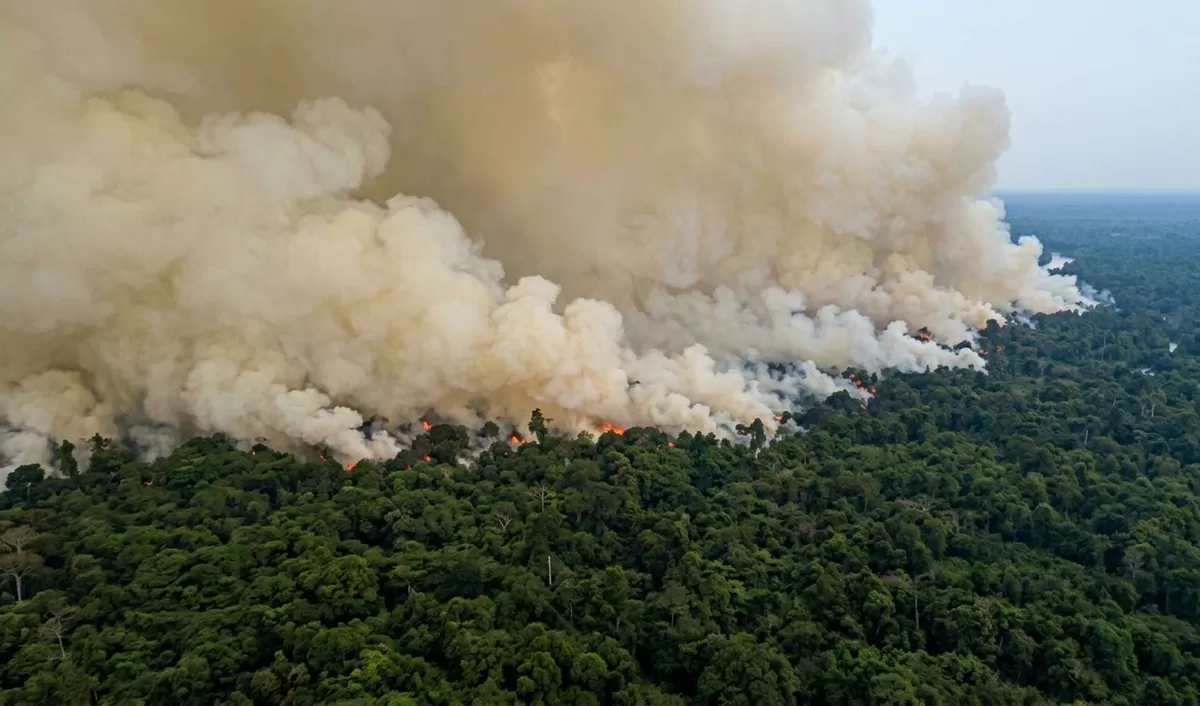
West Papua with six provinces, the final bastion of virgin tropical rainforest in Indonesia, is currently confronting an extraordinary environmental and social crisis. For centuries, West Papua’s nature presented a perfect harmony between its rich landscape and the indigenous communities guarding it. However, ambitious National Strategic Projects (PSN) focusing on food and energy security are drastically transforming the ecological harmony and socio-political dynamics of this region. Over the period from January to August 2026, severe West Papua Wildfires surged dramatically across Indonesia’s easternmost region. This disaster has fundamentally disrupted the bio-geophysical balance that long sustained local life.
Based on satellite monitoring datasets, the West Papuan region recorded a truly heartbreaking record. West Papua now dominates up to 55.2% of the total burned area within national food project concession boundaries across Indonesia (MapBiomas Fire Indonesia data). This statistic marks a tragic shift; the epicenters of forest fire disasters, which historically belonged to Sumatra and Kalimantan, have now officially shifted to Papua Island. Ambitions to achieve national food security through giant food estate schemes are driving this destructive environmental transformation in a structured and massive manner.
Spatial data and satellite mapping specifically highlight Merauke Regency in South Papua Province as the primary center of environmental severity. Satellite mapping confirms that Merauke Regency alone recorded an extraordinary burnt area of 57,809 hectares (Auriga Nusantara coalition data). This fantastic figure accounts for approximately 52% of all food project burned areas across the entire archipelago. These undeniable statistics officially place Merauke as the regency with the largest wildfire area record nationwide in 2026.
The expansion of mega-projects that ignore environmental carrying capacity leads directly to the destruction of vital ecosystems. Large-scale deforestation and massive water canal excavation destroy shallow peatland ecosystems that act as water-absorbing sponges, as well as wild sago forests (Metroxylon sagu) that serve as natural food reserves. Communities feel this destruction far beyond South Papua Province. The escalating damage spreads like a domino effect across all newly formed provinces in Papua Province, including Central Papua Province, Highland Papua Province, West Papua Province, Southwest Papua Province, and the parent Papua Province.
Beyond physical destruction, this escalating wildfire scale threatens a permanent loss of local culture (ethno-ecological erosion). The threat of identity extinction (ethnocide) now looms over the daily lives of indigenous communities, particularly the Marind, Asmat, and Dani tribes. Their entire social order, local economy, and spiritual practices depend entirely on the integrity of their ancestral customary forests. For these indigenous communities, ancestral forests and wetlands are not mere natural commodities that companies can convert into capital. Forests represent a living space, a natural pharmacy, and a source of independent food sovereignty holding irreplaceable cosmological value.
2. Dissecting Root Causes: Human Actions vs. Natural Vulnerabilities
In analyzing the escalating fire scale across West Papua, critical evaluation reveals a mutually worsening interaction between primary human-driven causes and supporting natural triggers. These fires are not accidental natural phenomena; they are the result of failed human engineering.
2.1. Primary Cause: Land Clearing Using Fire (Anthropogenic Activity)
Pure anthropogenic human intervention serves as the primary cause of this catastrophe. Forced, massive land clearing practices by corporate entities dominate this disaster. Field operators extensively use fire as a primary weapon to achieve rapid time efficiency and drastic operational cost cuts.
Companies closely integrate the burning of natural forests and wetlands with land preparation for government national food projects. These projects encompass food estate initiatives, national food reserve expansions, public paddy field creation programs, and integrated industrial sugarcane plantation openings. Field evidence reveals structured burning patterns: excavators pile logged wood remains in neat parallel lines, which workers burn sequentially to clear secondary vegetation rapidly (WALHI data). This modus operandi proves that these fires are not wild accidents from discarded cigarette butts, but rather a systematic method to re-engineer ecosystems across tens of thousands of hectares.
2.2. Supporting Cause: Climate Drought and Peatland Canalization Disasters
Intentionally ignited fires would not become a disaster of this magnitude without supporting causes. Supporting factors stem from bio-climatic conditions and hydrological modifications that fatally destroy ecosystem resilience.
Extreme drought intensified by El Niño climate anomalies collided directly with human mechanical interventions in the form of massive drainage canal excavation. Peatland ecosystems basically function as giant carbon and water reservoirs where organic matter remains wet and un-decomposed. However, companies must drain these peat swamps to plant rice or sugarcane. Canal construction drastically drains groundwater levels across Peatland Hydrological Units (KHG).
The effects of this artificial drying process are terrifying. Peat, which previously absorbed water like a sponge, becomes highly water-repellent (hydrophobic) when exposed to air and oxidized. Dried peat soil turns into a massive pile of biomass fuel that ignites with extreme ease. Consequently, fires do not merely burn surface trees; they creep slowly underground as ground fires. This underground burning creates fire-extinguishing challenges that humans cannot solve without heavy natural rainfall.
Chapter 3: Disaster Map — Comparing Food Projects and Wildfires Across West Papua, Borneo, and Sumatra
3.1. Indonesian Government National Food Projects (2024–2029)
During the 2024–2029 administration period, the Indonesian government is massively pushing agricultural expansion to achieve national food security and self-sufficiency. This mega-project ambition in the food sector relies on giant land clearing across various regions, directly disturbing bio-geophysical balances. Policy allocations cover millions of hectares across major islands, with specific targets per province as follows:
Land Allocation Across West Papua
Total food project allocations across all West Papuan provinces target a development area of approximately 2 million hectares:
- South Papua: Serves as the largest allocation zone, receiving approximately 1,000,000 to 1,200,000 hectares. This area functions as the largest National Food Strategic Project center based in Merauke and Wanam, including Production Forest (KHP) releases of roughly 474,000 hectares, alongside rice paddy creation and land optimization (oplah) targets reaching 48,934 hectares.
- Central Papua: Allocates approximately 15,000 to 25,000 hectares focusing on new paddy creation and agricultural land optimization.
- Papua (Parent Province): Holds a target area of 18,000 to 20,000 hectares, specifically covering paddy field creation in Keerom Regency and Jayapura Regency.
- West Papua Province: Receives a land clearing allocation of 12,000 to 15,000 hectares.
- Highland Papua: Targets 8,000 to 10,000 hectares to support local food security for highland communities.
- Southwest Papua: Allocates agricultural land development in the range of 5,000 to 8,000 hectares.
Land Allocation Across Borneo (Kalimantan)
Total land allocations for food projects and food forest reserves in Borneo exceed a cumulative 3 million hectares:
- Central Kalimantan: Bears the heaviest island allocation at approximately 2,390,000 hectares. The region provides national food reserves from forest zones, former Mega Rice Project (PLG) peatlands, existing food estate developments, and new paddy land clearing.
- West Kalimantan: Allocates roughly 300,000 to 400,000 hectares for food and energy forest reserves, alongside community paddy field network creation in Sambas, Landak, and Ketapang Regencies.
- South Kalimantan: Records allocations of 200,000 to 250,000 hectares dominated by swamp Land Optimization (Oplah) and Planting Area Expansion (PAT) programs.
- East Kalimantan: Allocates 100,000 to 150,000 hectares as a food buffer zone for Nusantara Capital City (IKN) and Production Forest zones.
- North Kalimantan: Receives 50,000 to 80,000 hectares focusing on border area, coastal, and transmigration paddy clearing.
Land Allocation Across Sumatra
Targeted government food project allocations across Sumatra exceed a cumulative 1.5 million hectares:
- South Sumatra: ~500,000–600,000 hectares, focusing nationally on tidal swamp Land Optimization (Oplah), new paddy creation, and national food reserves in Banyuasin, OKI, and Musi Banyuasin.
- Riau: ~200,000–250,000 hectares, for swamp paddy development and coastal tidal land optimization.
- Lampung: ~150,000–180,000 hectares, for cropping index increases and national food buffer zones.
- North Sumatra: ~120,000–150,000 hectares, covering horticulture food estates in Humbang Hasundutan, Pakpak Bharat, and North Tapanuli.
- Jambi: ~100,000–120,000 hectares, focusing on integrating community paddy creation and eastern coastal swamp optimization.
- Aceh: ~80,000–100,000 hectares, for new paddy creation and irrigation optimization in East Aceh, North Aceh, and Aceh Besar.
- West Sumatra: ~50,000–70,000 hectares, focusing on rice planting area intensification and expansion.
- Bengkulu: ~30,000–40,000 hectares.
- Bangka Belitung Islands: ~20,000–30,000 hectares, for new paddy development and local food independence.
- Riau Islands: ~5,000–10,000 hectares.
3.2. Forest and Land Wildfire Extent (Karhutla)
Monitoring data reveals that the epicenters of forest and land fire disasters are experiencing serious geographical shifts.
Borneo (Kalimantan) Wildfire Summary
Indicative wildfire areas across Borneo accumulated to over 78,000 hectares:
- West Kalimantan: 38,310.86 hectares (the largest wildfire extent in Borneo and Indonesia).
- South Kalimantan: 27,202.00 hectares (based on BPBD monitoring data).
- East Kalimantan: 8,713.00 hectares (total impacted area up to mid-October).
- Central Kalimantan: 7,634.46 hectares.
- North Kalimantan: 120.50 hectares.
West Papuan Territory Wildfire Summary
Indicative West Papua Wildfires accumulated to 33,797.54 hectares across West Papuan territories. Papua now dominates 55.2% of all fires within national food project concession boundaries nationwide:
- South Papua: 25,800.00 hectares (the largest epicenter of destruction dominated by savannas and peatlands). Concentration of projects in Merauke Regency directly drives this enormous land fire figure.
- Central Papua: 2,519.88 hectares (impacted by expanding extractive land clearing).
- West Papua Province: 2,496.39 hectares.
- Highland Papua: 1,681.43 hectares (including conservation zones and customary forests).
- Southwest Papua: 716.70 hectares.
- Papua (Parent Province): 544.61 hectares.
Sumatra Wildfire Summary
Indicative accumulated wildfire data across Sumatran provinces recorded the following impacts:
- Riau: 15,738.92 hectares (dominated by peatland zones).
- Riau Islands: 5,760.90 hectares.
- South Sumatra: 5,194.00 hectares (active areas undergoing aerial firefighting).
- Lampung: 3,315.00 hectares (including fire impacts in Way Kambas National Park).
- Jambi: 2,025.00 hectares.
- Aceh: 1,592.00 hectares.
Chapter 4: Comparative Analysis of Food Projects and Wildfire Impact Areas
4.1. Ecological Pressure Ratio and Regional Contribution Analysis
Evaluating the direct link between National Strategic Project expansion and escalating wildfire disasters relies on two main methodological approaches:
- Ecological Pressure Ratio Analysis As a striking comparison, the government tasked Central Kalimantan with supporting the largest food expansion burden nationally (~2.39 million hectares). However, spatial reality shows its wildfire extent at 7,634.46 hectares. Conversely, South Papua received a land clearing task of roughly 1.2 million hectares, yet experienced an extreme disaster with 25,800 hectares of burned land. This unequal ecological pressure ratio proves that South Papua’s peatlands and savannas possess far higher environmental vulnerability. It also demonstrates that combining forced land clearing methods with forced drainage canalization converts Papuan landscapes into mass biomass fuel.
- Regional Contribution and Proportion Mapping Proportion mapping confirms a tragic shift in Indonesia’s deforestation and wildfire maps. Out of all burned national food project concession areas, Papua absolute-dominates by taking a 55.2% proportion of total national damage. Even more significantly, Merauke Regency alone accounts for 52% of all land fires within national food zones nationwide. Outside Papua, West Kalimantan contributed the worst fire proportion in its region (38,310.86 hectares) despite receiving a smaller food allocation (300,000–400,000 hectares) than Central Kalimantan. This mapping clearly illustrates that the government disproportionately transfers environmental destruction from Western and Central Indonesia to drop heavily upon Eastern Indonesia’s rainforests.
4.2. Matrix Priority Conclusion for Land Clearing Regions Based on Wildfire Risk
Assessing the vast scale of natural destruction alongside ambitious government land targets leads to the absolute conclusion that giant food estate projects are transforming into ecological, social, and cultural disasters. Based on cross-analyzing food project data and wildfire impact areas, the government must immediately prioritize restructuring land clearing regional statuses.
Objective evaluation requires placing South Papua, West Kalimantan, and South Kalimantan into the “Highest Priority Evaluation Red Zone” matrix category. High ecological pressure ratios and massive burned area contributions in these provinces demand that the government tactically impose an immediate moratorium on primary natural forest clearing. Forcing continued land clearing in these red zone priorities will inevitably expand toxic haze pollution while worsening ecological and human rights crises, such as indigenous land marginalization and the loss of local sago food sovereignty. The government must shift its primary focus from raw paddy field quantitative targets to enforcing strict zero-burning land clearing (PLTB) regulations and initiating large-scale peatland restoration across impacted zones.
5. Domino Effects: Direct Impacts, Long-Term Consequences, and Global Threats
Massive orchestrated deforestation across Papua triggers a three-tiered domino effect that paralyzes various aspects of life, expanding far beyond village or regency boundaries.
5.1. Direct Impacts: Haze Encirclement and Wind Trajectory Analysis
The most suffocating direct impact on citizens is exposure to toxic haze pollution spreading across multiple provinces via atmospheric wind movements. HYSPLIT computer wind trajectory modeling combined with climate data reveals that strong Australian Monsoon winds dominated regional skies during the second half of 2026 (BMKG data).
Strong monsoon winds blowing from the southeastern Pacific Ocean acted as vectors carrying toxic fine particulate matter (PM2.5). Combined with dry weather and an absence of convective rain to wash the air, smoke from Merauke, Mappi, and Asmat invaded northwestern skies. Thick emission plumes polluted air in Central Papua, blanketed Highland Papua (including Wamena and Yahukimo), crossed marine boundaries, and degraded air quality in the neighboring Maluku Islands.
Polluted air triggered fatal disruptions across the aviation logistics sector. Extremely low visibility forced the closure of at least 16 pioneer airports across Papua (Ministry of Transportation data). Key carriers like Trigana Air cut cargo operations by 50 percent. Consequently, essential supplies like rice, Pertamina fuel, and PLN electrical equipment failed to reach isolated inland communities. From a health perspective, residents in dozens of villages suffered from a sharp spike in Acute Respiratory Infections (ISPA) as the Air Pollution Standard Index (ISPU) breached hazardous thresholds. Ecologically, dense smoke blanketed Lorentz National Park, directly threatening protected endemic wildlife habitats.
5.2. Future Impacts: Sago Loss and Customary Rights Erosion
Long-term peatland drainage causes irreversible hydrological function damage. Clean water sources become polluted and dry up. Crucially, projects uproot wild sago forests that form the pillar of local existence. The death of sago stands means losing food independence and severing intergenerational cultural transmission among Papuan indigenous clans.
Indigenous rights marginalization heavily characterizes these land clearing practices. Human rights audits documented at least 35 incidents of HR violations in Merauke’s food estate area (Pusaka Foundation data). Violations include rejecting Free, Prior, and Informed Consent (FPIC) principles, stripping customary land rights, and discriminating against indigenous women. Due to total forest loss, two customary clans completely lost their ancestral territories, forcing them to rent land or beg for food from neighboring tribes just to survive.
5.3. Global Impact: Emission Spikes and Eternal Snow Extinction
On a global scale, destroying millions of hectares of Papuan ecosystems accelerates the global climate crisis. Massive land extraction for Merauke food estates releases an estimated 782.45 million tons of carbon dioxide (CO2) emissions into the atmosphere (CELIOS data). Economic losses from this carbon emission overflow reach an estimated Rp 47.73 trillion.
Ironically, emission spikes from this mega-project directly contradict Indonesia’s international commitment to the UN to achieve a Net Sink in the forestry sector by 2030. Land conversion in Papua has completely exhausted the nation’s legal deforestation quota. Weather scientists strongly predict that regional warming anomalies driven by atmospheric degradation will cause the eternal ice and snow layers on Puncak Jaya to melt completely and go extinct by late 2026 or early 2027 (BMKG data).
6. On-Paper Policies vs. Field Realities
This massive environmental destruction indicates a total failure of state regulatory supervision regarding environmental protection.
Legally, Ministry of Agriculture Regulations (Permentan) mandate zero-burning land clearing (PLTB) policies for corporations. Regulations also require companies to deploy dozens of trained firefighters alongside giant water reservoirs holding 800 cubic meters per 500 hectares of land. However, surging hotspots and failed firefighting in Merauke prove that PLTB compliance remains a mere administrative paper requirement lacking field enforcement and strict sanctions.
Worse still, authorities ignored Strategic Environmental Risk Assessments from official state agencies (such as Bappenas) that classified Merauke’s PSN at the most extreme damage risk level. Conflict resolution mechanisms also reached a total deadlock. A class action lawsuit by the Malind Tribe at the Jayapura Administrative Court (PTUN) in 2026 attempting to halt road construction through customary forests ended in bitter defeat, legalizing land grabbing practices under the guise of national development.